
El Castillo
Also known as: El Castillo
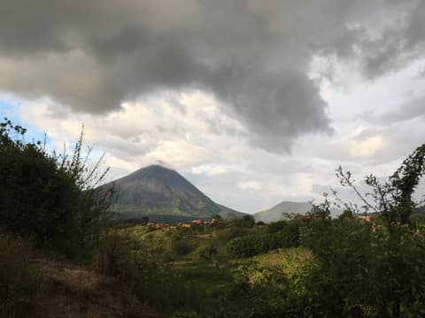
A small village on the lake's southern shore, on the far side of the volcano. Climbing its sloping streets rewards you with views of the lake and, on clear days, of Arenal.

What you can do for free
- Walk and wanderWalk up the village streets to see the lake from above, as travel guides recommend.
- See and photograph the volcanoOn clear days, see Arenal Volcano from around the village.
- Take in the lakeSee Lake Arenal from its southern shore.
El Castillo is a hamlet on the shores of Lake Arenal, on the other side of the volcano as seen from La Fortuna. According to OpenStreetMap it belongs to Peñas Blancas district, in San Ramón canton. One guide sums it up with the essentials of a rural Costa Rican village: a school, a church, a corner shop (pulpería) and a football field, plus a few hotels.
Walking around costs nothing. Travel guides recommend heading up its slopes for better lake views, and the Costa Rica Tourism Board (ICT) mini-guide lists a rented-bicycle ride to nearby towns such as El Castillo among the area's free activities. Almost everything else charges: the butterfly garden, zip-lines and private reserves.
Travel time varies by source: 20 to 40 minutes by car. One guide warns that part of the road is unpaved, and a May 2026 article with ICT information mentions a new bridge over the Caño Negro River that opens a tourist corridor towards Monteverde.
How to get there
By car, taxi or bicycle from La Fortuna, following your navigation app (about 23 km). Part of the road may be gravel. We found no public bus route with a reliable source.
Permitted access
A village with public roads. The surrounding hotels, reserves and farms are private. Do not enter without permission.
Terrain and conditions
Sloping streets. An undated guide says half the road from La Fortuna is unpaved; we do not know if that is still the case.
What to bring
- Comfortable shoes for walking uphill.
- Water. We did not verify any public facilities in the village.
Precautions
-
Many viewpoints in the area belong to hotels or businesses and charge. Respect private property.
-
Coatis frequently cross the roads near the national park. Drive carefully and do not feed them; feeding wildlife is prohibited.
Arenal Observatory Lodge — Getting to, Delfino.cr – Sala IV avala prohibición…
What we don't know yet
- Current state of the road (dirt or paved).
- Whether there is any public, non-commercial viewpoint in the village.
- A public bus route to El Castillo with a reliable source.
Sources
Every fact on this page comes from these sources. The date is when we checked them.
-
ICT — Mini guía La Fortuna (flipbook, p. 3)
Official
The rented-bicycle ride to El Castillo is listed among the ICT's free activities.
-
Travelers & Dreamers
Travel guide
Walk up the village slopes for the best lake views.
-
James Kaiser — El Castillo Hotels
Travel guide
A village with a school, church, pulpería and football field; 40 minutes with half the road unpaved.
-
Costa Rica Vibes — 30 Best Things to Do in La Fortuna
Travel guide
About 30 minutes by car from La Fortuna.
-
News in America (nota con fuente ICT)
National media
About 20 minutes according to the local chamber; new bridge over the Caño Negro River.
-
Earth Trekkers — Best Things to Do in La Fortuna
Travel guide
El Castillo's butterfly garden is a private attraction 30 minutes away.
-
OpenStreetMap — El Castillo (nodo 365508690)
Map
Location of the village and district according to OpenStreetMap.
-
Enrutador FOSSGIS/OSRM sobre datos de OpenStreetMap (routing.openstreetmap.de)
Map
Estimated driving distance from La Fortuna's central park.
Nearby
Arenal Dam (Sangregado Dam)
Dam and eastern lakeshore · 17.3 km · 21 min
The road to Nuevo Arenal and Tilarán runs over the dam that created today's Lake Arenal. From there you can see the reservoir and, on a clear day, the volcano behind it.