
Arenal Dam (Sangregado Dam)
Also known as: la represa · Represa Arenal · Presa Sangregado
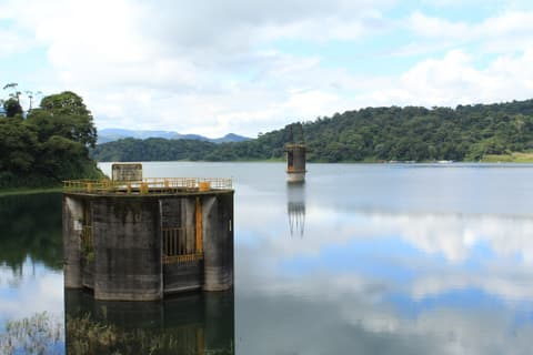
The road to Nuevo Arenal and Tilarán runs over the dam that created today's Lake Arenal. From there you can see the reservoir and, on a clear day, the volcano behind it.

What you can do for free
- Take in the lakeSee the lake from the road across the dam.
- See and photograph the volcanoOn a clear day, see Arenal Volcano beyond the lake, as local guides describe.
- Learn local historyUnderstand how today's lake was formed, through the ICE project inaugurated in 1979.
Arenal Dam, also called Sangregado Dam, is the Costa Rican Electricity Institute (ICE) project that joined a natural lake with an artificial reservoir and created today's 87 km² Lake Arenal. The plant was inaugurated on 9 December 1979. Route 142, the public road between La Fortuna, Nuevo Arenal and Tilarán, runs over it, so seeing it costs nothing: it is part of the drive.
Local guides and tour operators say people pull over to see the lake with the volcano behind it. We found no ICE or Ministry of Public Works (MOPT) rule on whether stopping or walking on the dam is allowed. Treat it as a view from the road and stop only where it is legal and safe, off the roadway.
Its history is also the area's history. The towns of Arenal and Tronadora were relocated to create the reservoir, and the Nuevo Arenal on the other side of the lake today was born from that move.
How to get there
From downtown La Fortuna, take Route 142 west towards the volcano and the lake. The road crosses the dam about 17 km later. There is a public bus between La Fortuna and Tilarán that runs along the lake, but we found no official timetable. Check at the bus station.
Permitted access
Public road (Route 142). We found no official ICE or MOPT rules on stopping or walking on the dam.
Terrain and conditions
Paved road. There is no information about sidewalks or an official parking area.
What to bring
- Water and a snack if you are continuing along the lake road. We did not verify any services at the dam.
Precautions
-
Do not stop on the roadway. Find a legal and safe place to pull over.
-
The road around the lake is paved but very winding.
-
In heavy rain, Route 142 has been temporarily closed by landslides, as happened in May 2017.
What we don't know yet
- ICE or MOPT rules on stopping or walking on the dam.
- Whether there is a safe and legal place to park nearby.
- Official timetable of the La Fortuna–Tilarán bus.
Sources
Every fact on this page comes from these sources. The date is when we checked them.
-
Seven Tours (operador turístico)
Travel guide
Route 142 crosses the dam; people pull over to see the lake with the volcano behind it.
-
ICT — Mini guía La Fortuna (flipbook, p. 3)
Official
The ICT mini-guide includes visiting Lake Arenal among the free activities.
-
Arenal Volcano Costa Rica (guía)
Travel guide
17 km from downtown La Fortuna on Route 142; there is a limited bus service to Tilarán.
-
Wikipedia — Presa Sangregado Dam
Wiki
Names of the dam (Arenal, Sangregado) and operator (ICE).
-
ICE — Sala de prensa: 'Arenal celebra 45 años…'
Official
The reservoir covers 87 km² (ICE, 2024).
-
Instituto Costarricense de Electricidad (ICE) – folleto 'Costa Rica: Un modelo sostenible, único en el mundo. Matriz eléctrica'
Official
The project joined a natural lake with an artificial one and relocated two towns.
-
La Nación
National media
Inauguration on 9 December 1979; relocation of Tronadora and Arenal.
-
OpenStreetMap — Presa Sangregado (vía 162630055)
Map
Location of the dam.
-
Enrutador FOSSGIS/OSRM sobre datos de OpenStreetMap (routing.openstreetmap.de)
Map
Estimated driving distance from the central park.
Nearby
El Castillo
El Castillo · 23 km · 34 min
A small village on the lake's southern shore, on the far side of the volcano. Climbing its sloping streets rewards you with views of the lake and, on clear days, of Arenal.
Nuevo Arenal
Nuevo Arenal · 45.6 km · 58 min
The town built for the families of old Arenal when the reservoir covered their original village. It sits on the lake's northern shore, roughly an hour's drive from La Fortuna.