
San Rafael de Guatuso
Also known as: Guatuso
Guatuso's main town, on the banks of the Frío River, with its central park and parish church. It is the base for trips to Caño Negro, Maleku territory or Río Celeste.

What you can do for free
- Walk and wanderWalk around downtown and the central park.
- Relax and watch local lifeWatch village life and the Frío River.
San Rafael is the main town of Guatuso canton and sits on the banks of the Frío River, with commercial and tourist services (ICT). Visit Costa Rica presents it as a starting point for trips to Caño Negro and the indigenous territories.
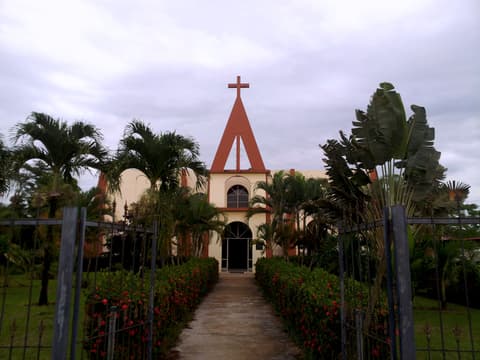
Downtown are the central park and the parish church of San Rafael Arcángel. According to the Guatuso municipality, the current church was built in 1993.
It is about 40 minutes from La Fortuna by car, so it makes an easy stop on Route 4 if you are heading to Upala, Caño Negro or the Río Celeste area (the attractions of Tenorio Volcano National Park and the Caño Negro refuge are paid).
How to get there
Along Route 4 (San Carlos–Guatuso–Upala).
Permitted access
A town with public streets; the central park and the parish church are downtown.
Precautions
-
Before going down to the Frío River, check SATRI, the river alert system linked by the Guatuso municipality.
What we don't know yet
- Whether there is public access to the Frío River's bank in town.
Sources
Every fact on this page comes from these sources. The date is when we checked them.
-
ICT — Guía turística Llanuras del Norte (flipbook, p. 68)
Official
Community on the Frío River with services.
-
Visit Costa Rica (ICT) – Atractivos de las Llanuras del Norte
Official
Starting point for Caño Negro and the indigenous territories.
-
Visit Costa Rica (ICT) – Mini guía de Bijagua y alrededores (PDF)
Official
Route 4 runs through Guatuso.
-
Municipalidad de Guatuso – Historia del cantón
Official
The current church was built in 1993.
-
Municipalidad de Guatuso – SATRI, alerta temprana de ríos Frío y Venado
Official
Alert system for the Frío and Venado rivers.
-
OpenStreetMap — Parque Central de San Rafael de Guatuso (vía 501278884)
Map
Location of the central park.
-
Enrutador FOSSGIS/OSRM sobre datos de OpenStreetMap (routing.openstreetmap.de)
Map
Estimated driving distance from La Fortuna's central park.